N
NASA
Guest
Earth Observatory
January 25, 2026
March 14, 2026

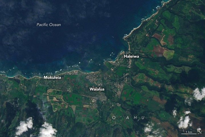
Coastal towns and green farmland are unaffected by floodwater, and the ocean is mostly blue.
NASA Earth Observatory / Lauren Dauphin

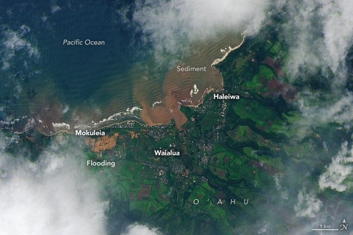
The same area, with brown floodwater pooling across farmland between Mokuleia and Waialua, with a red-brown plume spreading into the coastal ocean.
NASA Earth Observatory / Lauren Dauphin
January 25, 2026March 14, 2026
Coastal towns and green farmland are unaffected by floodwater, and the ocean is mostly blue.
NASA Earth Observatory / Lauren Dauphin
The same area, with brown floodwater pooling across farmland between Mokuleia and Waialua, with a red-brown plume spreading into the coastal ocean.
NASA Earth Observatory / Lauren Dauphin
January 25, 2026
March 14, 2026
January 25, 2026 – March 14, 2026
CurtainToggle2-Up
Image Details
Floodwaters pool in neighborhoods and on farmland, while a plume of sediment spreads into the coastal ocean (right) on March 14, 2026, after the first of two kona lows dropped copious rain on O’ahu, Hawaii. The same location is pictured free of floodwater (left) on January 25, 2026. Both images were acquired with the OLI (Operational Land Imager) on Landsat 9.
Back-to-back low-pressure systems struck Hawaii in March 2026, delivering some of the worst flooding the state has seen in decades. The subtropical weather systems—called kona lows near Hawaii—siphoned moisture from the tropics, fueling slow-moving thunderstorms with torrential, destructive rains.
The National Weather Service reported rainfall totals of 5 to 10 inches (13 to 26 centimeters) throughout the state between March 11 and 15, with some areas seeing more than 30 inches. Weather stations in Honolulu, Hilo, Līhuʻe, and Kahului all broke daily rainfall records.
The satellite image on the right shows swamped neighborhoods and farmland between Mokuleia and Waialua on the island of O’ahu on March 14, 2026, after the first and more destructive storm system hit the island. Plumes of suspended sediment have discolored waters in and around Kaiaka Bay. Hawaii’s volcanic Hilo soils are known for being red due to the high levels of iron and aluminum oxide that accumulate as they weather. For comparison, the image on the left shows the same area on January 25, 2026, before the deluge.
Preliminary assessments indicate that hundreds of homes in O’ahu sustained damage. Farmers on the island and across the state reported millions of dollars in damage, according to news reports. The storm produced widespread wind gusts between 60 and 75 miles (97 and 121 kilometers) per hour, with gusts in some places reaching 100 miles per hour. As many as 115,000 O’ahu residents faced power outages in the storm’s aftermath.
While the most intense rains had subsided by March 24, forecasters are continuing to monitor unsettled weather and the possibility of more flash floods in the coming days.
NASA’s Disasters Response Coordination System has been activated to support the Hawaii Emergency Management Agency’s response to the storms. The team will be posting maps and data products on its open-access mapping portal as new information becomes available.
NASA Earth Observatory images by Lauren Dauphin, using Landsat data from the U.S. Geological Survey. Story by Adam Voiland.

JPEG (3.99 MB)

JPEG (3.18 MB)
Stay up-to-date with the latest content from NASA as we explore the universe and discover more about our home planet.

A Winter Blanket Covers North Carolina
3 min read
In late January 2026, a strong, moisture-laden storm dropped snow across nearly the entire state, spanning from the Appalachians to…
Article

Wave of Dust Rolls Through Texas
3 min read
An advancing cold front kicked up a sharp line of sand and other small particles that swept over the high…
Article

Snow Buries the U.S. Interior and East
2 min read
Satellites observed a frozen landscape across much of the country after a massive winter storm.
Article
1
2
3
4
Next
Keep Exploring
Subscribe to Earth Observatory Newsletters
Subscribe to the Earth Observatory and get the Earth in your inbox.

Earth Observatory Image of the Day
NASA’s Earth Observatory brings you the Earth, every day, with in-depth stories and stunning imagery.

Explore Earth Science

Earth Science Data
Open access to NASA’s archive of Earth science data

Continue reading...
- Science
- Earth Observatory
- Kona Storms Flood Oʻahu
- Earth
- Earth Observatory
- Image of the Day
- EO Explorer
- Topics
- More Content
- About
- Search
January 25, 2026
March 14, 2026
Coastal towns and green farmland are unaffected by floodwater, and the ocean is mostly blue.
NASA Earth Observatory / Lauren Dauphin
The same area, with brown floodwater pooling across farmland between Mokuleia and Waialua, with a red-brown plume spreading into the coastal ocean.
NASA Earth Observatory / Lauren Dauphin
January 25, 2026March 14, 2026
Coastal towns and green farmland are unaffected by floodwater, and the ocean is mostly blue.
NASA Earth Observatory / Lauren Dauphin
The same area, with brown floodwater pooling across farmland between Mokuleia and Waialua, with a red-brown plume spreading into the coastal ocean.
NASA Earth Observatory / Lauren Dauphin
January 25, 2026
March 14, 2026
January 25, 2026 – March 14, 2026
CurtainToggle2-Up
Image Details
Floodwaters pool in neighborhoods and on farmland, while a plume of sediment spreads into the coastal ocean (right) on March 14, 2026, after the first of two kona lows dropped copious rain on O’ahu, Hawaii. The same location is pictured free of floodwater (left) on January 25, 2026. Both images were acquired with the OLI (Operational Land Imager) on Landsat 9.
Back-to-back low-pressure systems struck Hawaii in March 2026, delivering some of the worst flooding the state has seen in decades. The subtropical weather systems—called kona lows near Hawaii—siphoned moisture from the tropics, fueling slow-moving thunderstorms with torrential, destructive rains.
The National Weather Service reported rainfall totals of 5 to 10 inches (13 to 26 centimeters) throughout the state between March 11 and 15, with some areas seeing more than 30 inches. Weather stations in Honolulu, Hilo, Līhuʻe, and Kahului all broke daily rainfall records.
The satellite image on the right shows swamped neighborhoods and farmland between Mokuleia and Waialua on the island of O’ahu on March 14, 2026, after the first and more destructive storm system hit the island. Plumes of suspended sediment have discolored waters in and around Kaiaka Bay. Hawaii’s volcanic Hilo soils are known for being red due to the high levels of iron and aluminum oxide that accumulate as they weather. For comparison, the image on the left shows the same area on January 25, 2026, before the deluge.
Preliminary assessments indicate that hundreds of homes in O’ahu sustained damage. Farmers on the island and across the state reported millions of dollars in damage, according to news reports. The storm produced widespread wind gusts between 60 and 75 miles (97 and 121 kilometers) per hour, with gusts in some places reaching 100 miles per hour. As many as 115,000 O’ahu residents faced power outages in the storm’s aftermath.
While the most intense rains had subsided by March 24, forecasters are continuing to monitor unsettled weather and the possibility of more flash floods in the coming days.
NASA’s Disasters Response Coordination System has been activated to support the Hawaii Emergency Management Agency’s response to the storms. The team will be posting maps and data products on its open-access mapping portal as new information becomes available.
NASA Earth Observatory images by Lauren Dauphin, using Landsat data from the U.S. Geological Survey. Story by Adam Voiland.
Downloads
January 25, 2026
JPEG (3.99 MB)
March 14, 2026
JPEG (3.18 MB)
References & Resources
- Associated Press (2026, March 24) Here’s what to know as the scope of damage from Hawaii’s floods becomes clearer. Accessed March 24, 2026.
- City and County of Honolulu (2026) Kona Low Storm Recovery. Accessed March 24, 2026.
- County of Maui (2026) March Kona Storm Informational Page. Accessed March 24, 2026.
- FEMA, via Esri (2026) Flooding: Hawaii. Accessed March 24, 2026.
- Hawai‘i Emergency Management Agency (2026, March 16) March 2026 Kona Low. Accessed March 24, 2026.
- Honolulu Civil Beat (2026, March 23) Mud, Mud And More Mud: Residents Of Oʻahu’s North Shore Start To Dig Out. Accessed March 24, 2026.
- NASA (2026) Disasters Mapping Portal. Accessed March 24, 2026.
- NASA Earthdata (2025) Floods Learning Resources. Accessed March 24, 2026.
- National Weather Service (2026, March 16) Rainfall and wind summaries from March 10-16. Accessed March 24, 2026.
- National Weather Service (2026, March 16) State Forecast. Accessed March 24, 2026.
- USA Today (2026, March 24) Wild scenes from Hawaii’s worst flooding in 20 years. Accessed March 24, 2026.
You may also be interested in:
Stay up-to-date with the latest content from NASA as we explore the universe and discover more about our home planet.
A Winter Blanket Covers North Carolina
3 min read
In late January 2026, a strong, moisture-laden storm dropped snow across nearly the entire state, spanning from the Appalachians to…
Article
Wave of Dust Rolls Through Texas
3 min read
An advancing cold front kicked up a sharp line of sand and other small particles that swept over the high…
Article
Snow Buries the U.S. Interior and East
2 min read
Satellites observed a frozen landscape across much of the country after a massive winter storm.
Article
1
2
3
4
Next
Keep Exploring
Discover More from NASA Earth Science
Subscribe to Earth Observatory Newsletters
Subscribe to the Earth Observatory and get the Earth in your inbox.
Earth Observatory Image of the Day
NASA’s Earth Observatory brings you the Earth, every day, with in-depth stories and stunning imagery.
Explore Earth Science
Earth Science Data
Open access to NASA’s archive of Earth science data
Continue reading...